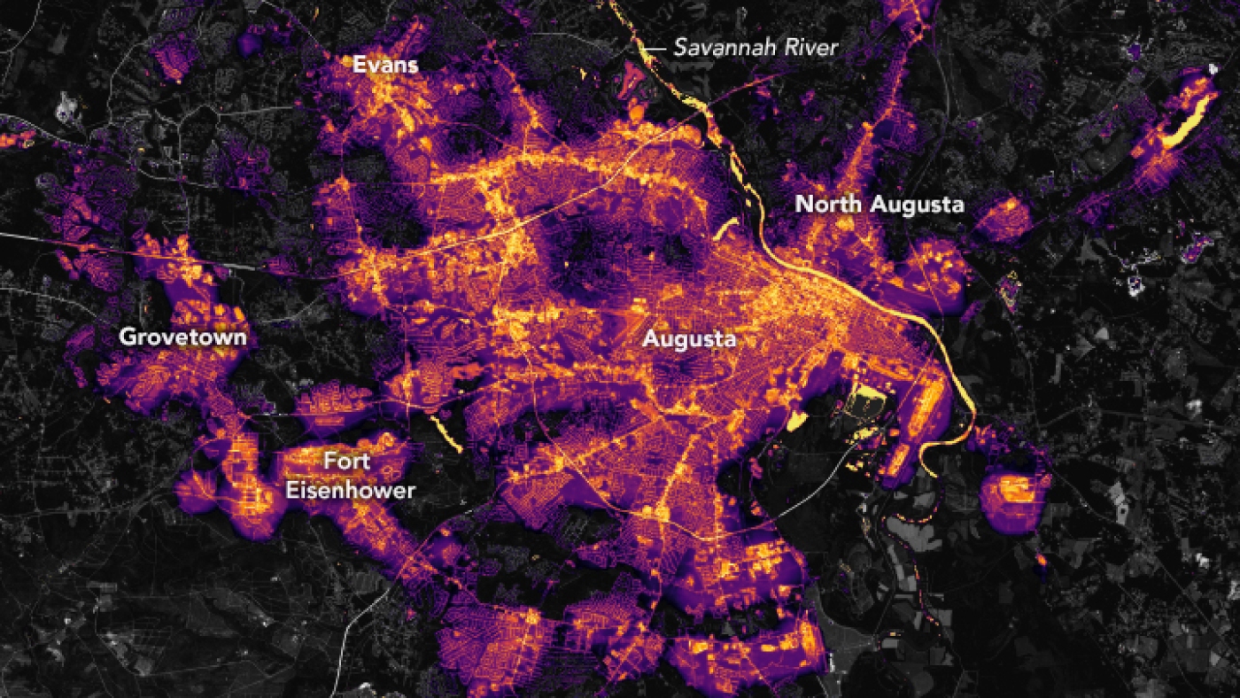
A satellite image shows Augusta, Ga., one month before Helene’s arrival plunged it and many other cities into darkness.
NASA Earth Observatory images by Lauren Dauphin, using Black Marble data courtesy of Ranjay Shrestha/NASA Goddard Space Flight Center
hide caption
toggle caption
NASA Earth Observatory images by Lauren Dauphin, using Black Marble data courtesy of Ranjay Shrestha/NASA Goddard Space Flight Center
Hurricane Helene left a trail of destruction and flooding in its wake, scouring a broad path through the Southeast and leaving a death toll that has climbed as emergency teams reach areas cut off by the storm.
Many of Heleneâs effects are individual and heartbreaking, such as the loss of children and grandparents, homes and businesses. But the storm also wrecked whole towns and communities, and its wider impact is so outsized that itâs clearly visible from space.
Satellite photos shared by NASA and NOAA show the fast-moving hurricane carved a dark corridor into the Southeast as its center roared inland, plunging cities and entire areas into blackouts.
In one striking set of images, Augusta, Ga., is seen going from a glowing metropolis to a largely blacked-out city, with the largest cluster of working lights centered on its downtown along the Savannah River.

People in Augusta, Ga., have been dealing with electricity and water outages since Helene rampaged through the area in late September.
NASA Earth Observatory images by Lauren Dauphin, using Black Marble data courtesy of Ranjay Shrestha/NASA Goddard Space Flight Center
hide caption
toggle caption
NASA Earth Observatory images by Lauren Dauphin, using Black Marble data courtesy of Ranjay Shrestha/NASA Goddard Space Flight Center
The NASA Earth Observatory images use data from the Black Marble Project, which filters out reflected or distorted light.
When Helene made landfall as a Category 4 storm near Perry, Fla., late on the night of Sept. 26, the system rushed inland at speeds topping 30 mph, inflicting the perils of a barely diminished tropical storm on areas far from the coast. Making matters worse, many of those interior, elevated areas were already water-logged from rains earlier in the week.
Satellite images from Sept. 25 and 28 â one day before landfall and more than one day afterward â show how power outages thrust parts of Florida, Georgia, South Carolina and North Carolina into darkness.
Satellite images from the #VIIRS Day-Night band onboard the #NOAA20 satellite reveal Hurricane #Helene‘s impact.
Before and after images from Sept. 25 and 28, 2024, highlight power outages in parts of Florida, Georgia, and both South and North Carolina. pic.twitter.com/9m2J6y2RMJ
— Joint Polar Satellite System (JPSS) (@JPSSProgram) September 30, 2024
More than a week after landfall, utility crews who rushed from near and far to turn lights and power back on have restored electricity to millions of people, but some areas are still waiting for help.
As of 10:30 a.m. ET Friday â more than a week after landfall â nearly 735,000 electricity accounts were still without power across five states, according to Poweroutage.us: South Carolina (273,913), North Carolina (230,448), Georgia (203,111), Florida (13,794), and Virginia (13,191).
Helene also changed the way the water looks in the Gulf of Mexico, along Floridaâs Big Bend area and much of its Gulf coastline. Three days after landfall, the effects were still dramatically visible, in waters that went from mainly clear to light blue, brown and green.

Before Helene’s arrival, waters along Florida’s Gulf Coast were largely clear â but sediment and particles later clouded a huge portion of water as the storm passed through.
NASA Earth Observatory images by Michala Garrison, using MODIS and PACE data from NASA EOSDIS LANCE and GIBS/Worldview
hide caption
toggle caption
NASA Earth Observatory images by Michala Garrison, using MODIS and PACE data from NASA EOSDIS LANCE and GIBS/Worldview
âHeleneâs winds and waves churned up sediment from the seafloor along shallow coastal areas,â according to the NASA Earth Observatory. âLight reflects from these fine particles and makes the water appear bright blue. Storm surge, flooded rivers, and flash floods produced runoff that eroded land surfaces and carried even more particles into the ocean, adding to the color.â

Hurricane Helene stirred up ocean sediment and flushed organic matter into the Gulf of Mexico, as seen in these images from NASA Earth Observatory.
hide caption
toggle caption
The agency says the wide ribbon of brown and green colors along the coastline is likely from dissolved organic materials.
âThe regionâs blackwater rivers, for example, are rich with decaying vegetation and other organic matter, and their stained water can become flushed into the ocean during heavy rains,â the NASA Earth Observatory says.


